Morning Glory Cloud
Text: Garry Benson
Photos: Various authors, attributed where possible
In Northern Australia, between September and November, an extraordinary phenomenon of unparalleled beauty occurs: the Morning Glory Cloud.
Morning Glory Cloud approaching Kangaroo Point, 1993
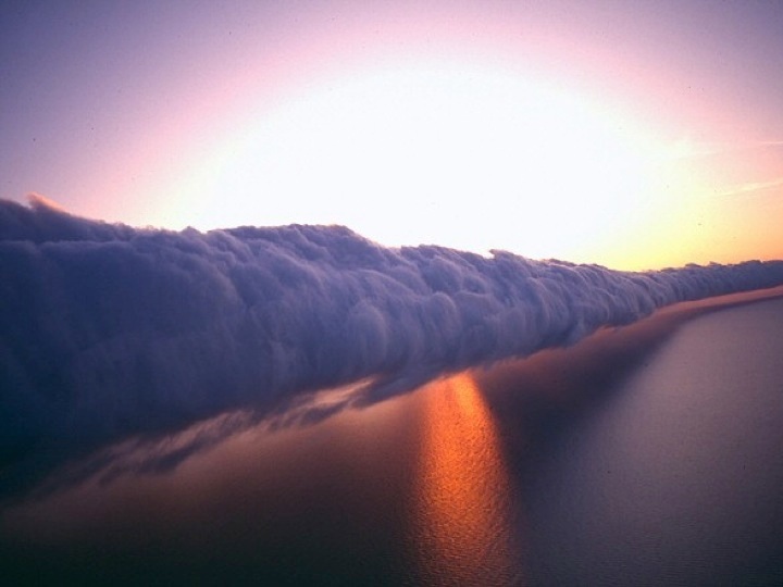
If the weather situation is calm, every morning when the sun rises, a wave-shaped cloud, 1.6 to 3.2 kilometres high and 600 to 1,000 kilometres, i.e, that it fills the horizon, moving at a speed of 40 kilometres per hour.

Photo credit: Unknown
Sometimes there are several waves and always aligned from east to west. The cause is a clash of air masses of different temperatures.

Photo credit: Mick Petroff
In the early hours of the morning, a mass of warm, moist air, from the sea, slips over the cooler air that is in the upper layers.

Photo credit: Unknown
In late 2006, scientists from several countries travelled to study the phenomenon, which occurs in many places in the world. It has been observed on the Catalan coast of Spain.

Photo credit: Unknown
The clash of air masses also takes place in Spain, but does not result in the formation of this peculiar cloud. This phenomenon is unique to Australia.

Photo credit: Unknown
Since 1989, every spring, when the phenomenon occurs, hang-gliders and para-gliders cloud surf waves like waves in an ocean.

Photo credit: Unknown
You have to be careful because the waves produce strong turbulence and can be dangerous. They fly in zigzag patterns and can travel up to 480 kilometres.

Photo credit: © J. Eduardo Juárez Herrerá
References
Morning Glory Articles (http://dropbears.com/m/morning_glory/articles.htm) (accessed 20 April 2014)
What’s the story Morning Glory? Sydney Morning Herald, (http://www.smh.com.au/environment/whats-the-story-morning-glory-20090825-exlt.html) (accessed 20 April 2014)