365 Places: Aspley
Day 9: Aspley, Queensland, Australia
Today’s post is about a place where I spent some of my formative years, a suburb in Brisbane, Aspley.
When I was a child, Aspley was considered the ‘gateway’ to the north – as it is located on both sides of the Gympie Road which turns into the Bruce Highway – or Highway 1. This is the road that takes you from Brisbane all the way to the Cairns and beyond.
As a child much of the land around me was rural or bush, making it an ideal place to play and explore, despite the highway being close by. We spent many hours down at Cabbage Tree creek, looking for guppies and frogs. When I went back to Brisbane as an adult, I was shocked and surprised to see how much this suburb had changed. This realisation led to the development of a performance work, titled Scalpland, which I reflected upon when I participated in the SCANZ2013 residency. My blog post Contemplating SCANZ2013 Themes – Revisiting Scalpland explored my connection to this place and its history.
As a kid I loved escaping to the bushland close by, and I remember getting in trouble for making a gunyah (cubby house) down in the bush behind the school. The picture below is of the school in the 1890s and you can see the magnificent trees in the background.
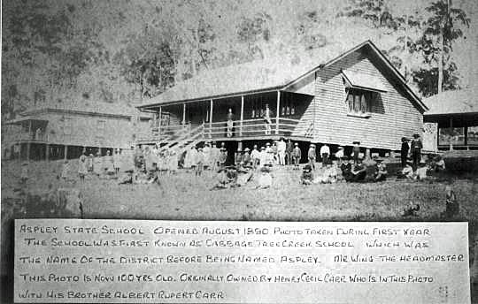
Aspley School, 1890. This photo was originally owned by Henry Cecil Carr, who is in this photo with his brother Albert Rupert Carr.
One of the very interesting things I found out was that Gympie Road and Albany Creek Road were Aboriginal tracks. The creek where I played as a child was a meeting place and crossroad for potentially tens of thousands of years. Mr Wikipedia states:
Soon after Brisbane was declared a free settlement in 1842, people began exploring the lands north of Brisbane City. A northern route followed aboriginal tracks through what is now Kelvin Grove, Enoggera, Everton Hills, Albany Creek onto North Pine. This route is still known as “‘Old Northern Road’” and “‘Old North Road’” in places.
Another aboriginal track branching eastward from the Old Northern Road at the South Pine River crossed towards Little Cabbage Tree Creek and continued towards Downfall Creek. This track is now known as “Albany Creek Road” and “Gympie Road”. Albany Creek Road was known as “Chinaman Creek Road” before 1888.
Here is a map of where the tracks used to be, the line in the centre is Maundrell Tce (my street) with my house highlighted.

Ancient Tracks
When I go back to Brisbane, invariably we still drive through Aspley and it is a place rich of memories and daydreams of the past.
Resources
Chermside and District History http://www.chermsidedistrict.org.au/chermsidedistrict/01_cms/details.asp?ID=129 (accessed 28 April 2014)
Check out these websites for more information:
http://queenslandplaces.com.au/node/39
http://www.chermsidedistrict.org.au/chermsidedistrict/default.asp